Description
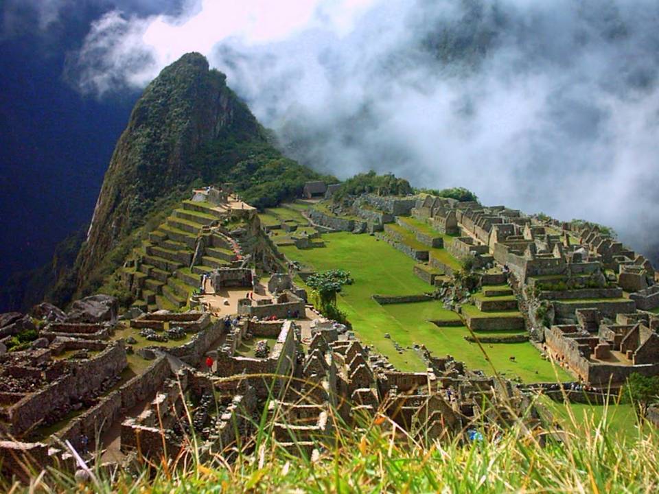
Machu Picchu, one of the wonders of the modern world, is one of the archaeological sites that attract much interest around the world, is without doubt the greatest example of the work and dedication of the Andean people. Surrounded by a great forest and towering mountains, mystery and enigma that captures the fortress on the visitors causes different feelings and emotions that go beyond mere admiration.

View of Machu Picchu from the house of the Guardian.
There are many theories to explain what was Machu Picchu, one of them is one that suggests it was a place where they were holding Ñustas or Virgins of the Sun, so that was one reason to be a secret place, this theory still holds because when the Spanish arrived, the Inca government, in order to prevent crime, hid these virgins in a secret location in the Andes, this place was the citadel of Machu Picchu, this theory also explains the discovery of 107 bodies and 68.9% of these were female.
Location: The archaeological site is located on the left side Vilcanota River, in the throat of Kusichaca, in the district of Machu Picchu, the province of Urubamba, department of Cusco.
Altitude is 2490 meters above the sea.
Temperature: It is situated in a subtropical area, the temperature rises from 8 º to 22 º C.
Distance: 112 km from the city of Cusco.
Tickets: The cost of entry to the citadel of Machu Picchu is $ 45 for foreign tourists and S/. 64 and S/. 32 for Peruvian tourists (adults and students respectively).


View of Machu Picchu from Huayna Picchu.
 |
There are several known ways to reach Machu Picchu. The first is the traditional - Train can be taken from the city of Cusco, the route to the Inca city is three hours. Take the train that leads directly to the town of Aguas Calientes, have different schedules from 6:00 am to 7:00 am, and from there go up a certain section in 20 minutes by bus or walking down a path well signposted for 1 ½ hours.
Another option for those who like adventure travel to visit Machu Picchu is to make the Inca Trail, following the route of 40 km. the way that the Incas made and used to communicate in this area, walking for 3 or 4 days and requires a great effort, visiting beautiful places in the Andes and the jungle. It starts at Km 88 of the railway to the Valley of the Convention, at a place called Q'oriwayrachina.
There are two other options for getting to Machu Picchu: walking along the railroad from Cuzco or combining a bus or truck route and even walk through the town of Santa Maria to Aguas Calientes.
On how to get to Machu Picchu expand in more detail in another post.

The fastest way to get to Cusco: by train

The other way is also more familiar: the Inca Trail or Inka Trail.

You can also walk to Machu Picchu along the railroad
tracks between 09 to 11 hours.

The route through Santa Teresa implies that even
will have to pull a hanging basket and cross the river
Vilcanota pure pulse. A cheap route
but only for those who like adventure total.
will have to pull a hanging basket and cross the river
Vilcanota pure pulse. A cheap route
but only for those who like adventure total.
History of Machu Picchu
Around 1440 the Inca Pachacutec (the one that dominates everything) conquest reaches the creek Picchu during his campaign to Vilcabamba, the site had peculiar geographical features, being impressed with the Inca had ordered to be built there, to a complex urban buildings of civil and religious luxury.
Around 1440 the Inca Pachacutec (the one that dominates everything) conquest reaches the creek Picchu during his campaign to Vilcabamba, the site had peculiar geographical features, being impressed with the Inca had ordered to be built there, to a complex urban buildings of civil and religious luxury.

Is 13 º 9 '47" south latitude and 72 º 32' 44" west longitude. District is part of the same name. Machu Picchu would have been one of the residences rest of Pachacutec (1438-1470). However, some of its finest buildings and ceremonial evident demonstrate that it was used as a religious shrine. Also true that recent studies based on archival documents of the sixteenth century have provided good and new arguments to determine that the citadel of Machu Picchu was, like the pyramids of the pharaohs of Egypt or the tomb of Chinese Emperor Shi Huang Chi , a luxurious and well cared for mausoleum to receive the remains of King Pachacutec.
During the Spanish occupation is estimated that the main noble Picchu then have left the city Manco Inca leader of the resistance in 1536 summoned the nobles from nearby regions to join his court in exile of Vilcabamba. According to documents suggest that the region would have remained inhabited Picchu since it was considered a tributary population in the Spanish encomienda of Ollantaytambo.
After the fall of the kingdom of Vilcabamba in 1572 and the consolidation of Spanish power in the Central Andes, Machu Picchu remained within the jurisdiction of different colonial estates changed hands several times until the time Republicans. However, it had become a remote location, away from the new roads and economic centers of Peru. The region was largely ignored by the colonial regime (not ordered the building of Christian churches or administer any town in the area), but not by the Andean people.
Nearly three centuries after the Italian naturalist Antonio Raimondi reach Machu Picchu without knowing it and says it was then sparsely populated region. But everything indicates that it is in those years when the area began to receive visits by interests other than the purely scientific.
Agustín Lizárraga, a tenant of land Cusco, arrived at the site on July 14, 1902 guiding the Cusco also Gabino Sánchez, and Justo Enrique Ochoa Palma graffiti they left their names in one of the walls of the Temple of Three Windows that was later verified by several people and there are reports suggesting that Lizarraga had visited Machu Picchu in the company of Luis Bejar in 1894. Lizárraga constructs showed them the "visitors", although the nature of operations has so far been investigated.


Hiram Bingham

Hiram Bingham

Hiram Bingham to Machu Picchu arrives June 24, 1911, although not the only precursor of the discovery, undoubtedly had the merit of being the first person to recognize the importance of the ruins, studying with a multidisciplinary team and disseminating their findings.

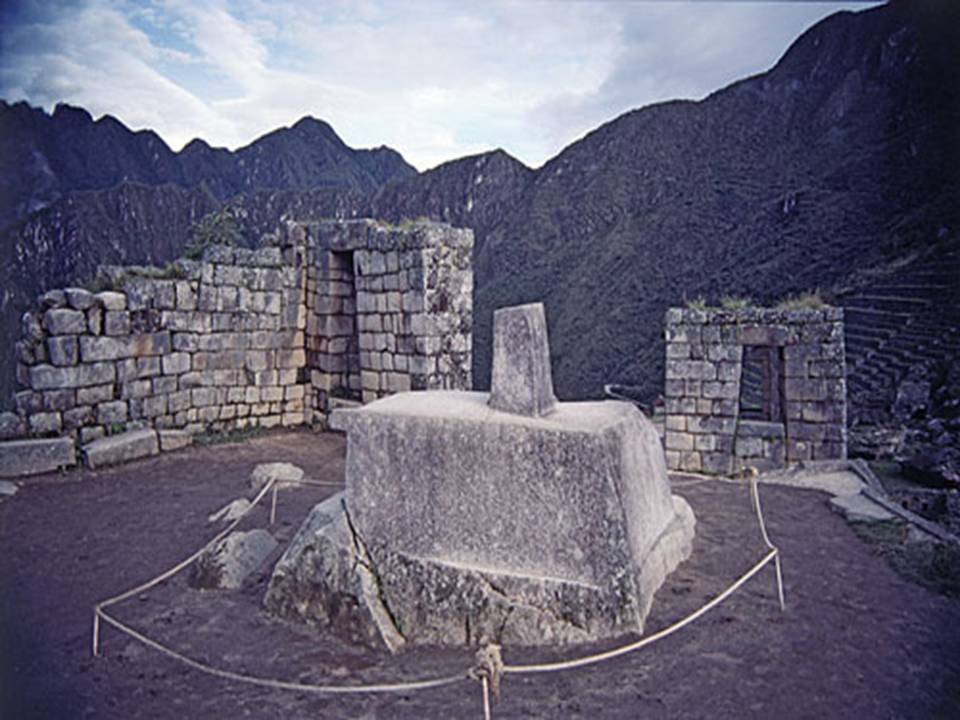
Today Machu Picchu is one of the great wonders of the world, since 1983 a member in the World Heritage List since 1981 and is an ecological protection zone, but still the Peruvian authorities have to contend with the latent problems in the area such as forest fires, conservation of endangered species and constant maintenance of the ruins.
In 2007, the government of Peru declared on 7 July as the "Day of the Historic Sanctuary of Machu Picchu New Wonder of the World" since the July 7, 2007 Machu Picchu was named one of the winners in the list of Wonders of the World.


Sources:
http://www.perucontact.com/
http://www.unique-southamerica-travel-experience.com/cusco.html
http://eldiwan2010.blogspot.com/2010_10_01_archive.html
http://www.covitour.com.pe/
http://www.grupoavych.com/cusco
http://imagenes.viajeros.com/fotos
http://wiki.sumaqperu.com/es/Qenko
http://www.delange.org/Quenko/Quenko.htm
http://images.travelpod.com/
http://es.wikipedia.org/wiki/
http://www.moon.com/files/map-images/
http://www.aatccusco.com/mapas_y_planos.php
http://cuscotravelinfo.wordpress.com/
http://www.cusco-peru.org/
http://www.cuscoonline.com/
http://www.pasaporteblog.com/
http://cuzco-peru.travel/
http://perudanzas.espacioblog.com/
http://www.aboutcusco.com/
http://www.livinginperu.com/blogs/travel/1484
http://skyscraperperu.com/
http://arquitecturaytecnologia2007.blogspot.com/
http://peruahora.wordpress.com/2008/10/23/breve-resena-de-machu-picchu/
http://www.amautacunadehistoria.com/2008/12/machu-picchu-en-new-york-times.html
http://www.labyrinthina.com/hb2.jpg
http://lastdaysoftheincas.com/wordpress/wp-content/uploads/2008/07/machu-picchu-overhead-by-bingham-overgrown-1912-copy.jpg
RELATED READINGS
Cusco: Meaning, Location and Size, Boundaries, Distances, Weather, History, the ancient Inca city
Cusco comes from the Quechua word QOSQO meaning navel, is credited with many meanings including mestizo chronicler Inca Garcilaso de la Vega who attributes the meaning of "center or navel of the world." ... Read more
Cusco: Nearby Attractions
The city of Cusco, whose name in Quechua is Qosqo, is the historical capital of Peru. It is located in the southern highlands. It now has a population of approximately 300,000 and is the largest tourist destination in Peru. Was capital of the Inca Empire and declared ... Read More
Most Popular Tourist Attractions
Sacred Valley of the Incas
The Sacred Valley of the Incas is composed of many rivers flowing through gorges and valleys, has many archaeological monuments and indigenous peoples. ... Read more
Other major attractions near the city of Cusco.
Raqchi
Following the path to the east of the city on the road to Puno, at km 125 is Raqchi population, which belongs to the district of San Pedro de Cacha Canchis province. Raqchi is located on the left bank of the river Vilcanota at a height of 3500 mts., apparently pre-Columbian ... Read more
Cusco: Meaning, Location and Size, Boundaries, Distances, Weather, History, the ancient Inca city
Cusco comes from the Quechua word QOSQO meaning navel, is credited with many meanings including mestizo chronicler Inca Garcilaso de la Vega who attributes the meaning of "center or navel of the world." ... Read more
Cusco: Nearby Attractions
The city of Cusco, whose name in Quechua is Qosqo, is the historical capital of Peru. It is located in the southern highlands. It now has a population of approximately 300,000 and is the largest tourist destination in Peru. Was capital of the Inca Empire and declared ... Read More
Most Popular Tourist Attractions
Sacred Valley of the Incas
The Sacred Valley of the Incas is composed of many rivers flowing through gorges and valleys, has many archaeological monuments and indigenous peoples. ... Read more
Other major attractions near the city of Cusco.
Raqchi
Following the path to the east of the city on the road to Puno, at km 125 is Raqchi population, which belongs to the district of San Pedro de Cacha Canchis province. Raqchi is located on the left bank of the river Vilcanota at a height of 3500 mts., apparently pre-Columbian ... Read more
Other attractions Sightseeing in Cusco Department
Choquequirao: Gold Mine
It is located 3033 meters above sea level in the foothills of Mount Salkantay, north of the Apurimac River valley, in the province of the Convention in the department of Cusco. Choquequirao environment is one of the richest in ... Read more
Getting to Machu Picchu by Train.
One trip you will never forget is that you make to Machu Picchu, the sacred citadel of the Incas. The trip is made by train from Cusco or from the village of Ollantaytambo to Aguas Calientes visiting interesting and picturesque villages. There are several train services ... Read more
One trip you will never forget is that you make to Machu Picchu, the sacred citadel of the Incas. The trip is made by train from Cusco or from the village of Ollantaytambo to Aguas Calientes visiting interesting and picturesque villages. There are several train services ... Read more
Getting to Machu Picchu along the Inca Trail (1)
The Inca Trail is a walk that starts from the legendary 82 km, near Ollantaytambo, includes a path along which you can find different ecoregions, altitude, temperature range and unforgettable panoramas that will make your visit an unforgettable experience, the path that ... Read more
Getting to Machu Picchu along the Inca Trail (2)
Entry Costs
The prices seen below are only the ticket price for entry to the Inca Trail route, does not include other ... Read moreEntry Costs