Sacred Valley of the Incas
The Sacred Valley of the Incas is composed of many rivers flowing through gorges and valleys, has many archaeological monuments and indigenous peoples.
The valley was appreciated by the Incas due to its special geographical and climatic qualities. He was one of the main points of production by the richness of their land and place where it produces the best maize in Peru.
In the Sacred Valley of the Incas spread beautiful colonial towns that were created, and now show their fusion of architecture, art and culture alive. There are villages in Chinchero and weavers, and craft fair Pisac, Urubamba and cosmopolitanism, Ollantaytambo, with its strength and Inca people live. Maras and Moray with its dazzling salt pans, in these territories, the Sacred Valley, several communities have created products of rural tourism and experiential Tourism astounding friends and strangers. Each is a world unto itself, and together make up a new way of exploring the region's most traditional South American Andes
The Sacred Valley is between the towns of Pisac and Ollantaytambo, parallel to the river Vilcanota. You can access it from the city of Cusco.

The Sacred Valley of the Incas is one of the most agricultural
production empire.

The Incas built circular platforms to improve
agricultural production
 Map of the Sacred Valley of the Incas: Roads
 Map of the Sacred Valley of the Incas: archaeological ruins,
 hot springs, camping
Pisac
Pisac is a district of the province of Calca, located 32 miles northwest of Cuzco. Its height includes the 2.950 meters. Pisac is an important archaeological site where it joins Inca buildings and beautiful natural wealth of the Valley of Urubamba. As was customary in Inca architecture, cities were built on the basis of animal figurative strokes. Pisac, was shaped like a partridge, as indicated by its name.
Archaeological Pisac is one of the most beautiful monumental places of the valley as it combines the strange shapes of the mountain where it meets the impeccable finish of the buildings. It is located on the highest hill in the city, on a dry and rocky.

On the upper terraces of Pisac.
Next to Cusco and Piquillacta, Pisac closes a triangle of 33 km side, precisely planned to protect the city from possible attacks of the Antis (Anti derived from "Andes" or mountains), who were their worst enemies. As in other Inca constructions, some studies report that it was not a fortress, but a kind of "real estate" owned by the Inca Pachacutec, comprising platforms, domestic and ceremonial structures, and aqueducts that provided the water for agriculture.
It can be seen, a great wall, the foundations of a tunnel, terraces, reservoirs, Inca cemetery, and the Intihuatana, which is one of the most important ceremonial monuments in Pisac, the location from the top of the mountain, dominates much the valley, is a circular building, the center is carved in stone Intihuatana, which was used as an observatory to determine the solar motion and specify the dates of the equinoxes and solstices, likewise determine the time of harvest and planting. This altar is oriented toward the sun being that this construction is very similar to Intihuatana of Machu Picchu.
It can be seen, a great wall, the foundations of a tunnel, terraces, reservoirs, Inca cemetery, and the Intihuatana, which is one of the most important ceremonial monuments in Pisac, the location from the top of the mountain, dominates much the valley, is a circular building, the center is carved in stone Intihuatana, which was used as an observatory to determine the solar motion and specify the dates of the equinoxes and solstices, likewise determine the time of harvest and planting. This altar is oriented toward the sun being that this construction is very similar to Intihuatana of Machu Picchu.

The archaeological ruins of Pisac.
Another major attraction is the village of Pisac, which, like every town in the Andes, has a beautiful church and a typical Sunday market, where bystanders are bringing all their products to offer in the market. Formerly, the custom was to exchange these products, people living on the heights of Pisac with the products of people living on the slopes, at present, the town has been producing ceramics such as vases, dishes, games, and tissues, which are sold to visitors.
To reach the village of Pisac, going by car, bus, take Tullumayu street, the fare is approximately S/.2 soles and the trip lasts 45 minutes, you can also take a taxi to go more faster and more direct, a taxi will charge about S/.40 soles and the journey will take half an hour.
After visiting the village and participate in the fair, if they go to the archaeological group takes a taxi that will take them 10 soles per person, the trip takes about half an hour. It is recommended going to the Pisac Fair on Sundays, Tuesdays and Thursdays are market days.
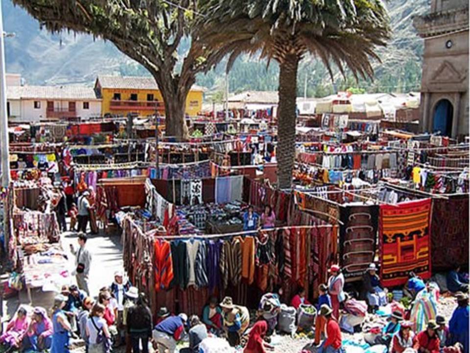
Pisac Fair, where you can buy handicrafts, souvenirs and other memorabilia
Pisac's main square is a fun place full of color and various items for sale. This village is famous for its astronomical observatory. Pisac is a mestizo village built on indigenous remains by Viceroy Francisco de Toledo (the same as that approved the dismemberment of Tupac Amaru. In Pisac, you can attend a mass in Quechua indigenous amid Varayocs or regional mayors. Likewise, agronomists can see how the Incas solved the problem of planting on the slopes of the hills.
Urubamba
The capital of the province of Urubamba has the same name and is located 57 km. northwest of the city of Cusco, on the road to Chinchero and Pisac. It is 2,875 meters high on a beautiful plain in the valley that separates the Central Cordillera of the Andes, the East, on the right bank of the river Urubamba. The town is located in the Sacred Valley. In pre-Hispanic times was a very important agricultural center. Today, its economy based on agriculture and tourism as one of the friendliest in the valley.
Paradise Bible considered by the great eighteenth century naturalist Antonio de Leon Pinelo, the city of Urubamba is today one of the most beautiful cities in the Sacred Valley of the Incas.
It is crossed by the river Vilcanota, that by entering this area takes its name from Urubamba.
The Incas, as connoisseurs of the land, chose this fertile valley to establish their main settlements, which is why the province of Urubamba is formed by the district where the main architectural monuments of the empire: Urubamba, Ollantaytambo, Chinchero Huayllabamba , Machupicchu, Maras and Yucay.

Urubamba Church

City of Urubamba

Urubamba River renamed in his round and was renamed Vilcanota River.
Urubamba was one of the major agricultural centers of the Inca Empire. In the city, adjacent to the monumental church of San Francisco, are the huge Inca platforms that we can still admire. You can also see some pre-Hispanic walls, which formed the foundation and basis for colonial buildings.
This city has a perfect climate all year round and has a beautiful landscape with a panoramic view of the valley and the towering peaks of the Cordillera Vilcanota. It is a great place to practice adventure tourism: hiking, canoeing, mountain biking and horseback riding interesting.
Chincheros
A 30 km north of the city of Cusco, on a paved road, one reaches the town of Chincheros (3,762 meters), this town of Inca origin and is surrounded by snow with Chicon, Pumahuanca, Sawasiray, Pitusiray. Chincheros has a rich cultural and architectural heritage. It is one of the few places in Cusco visibly retaining the Inca urban design. The remains of the Inca palace, the colonial church built on stone foundation, impeccable terraces and a colorful Sunday market are the main attractions.
The Main Square (Plaza de Armas) holds a huge Inca wall decorated with ten large trapezoidal niches in perfect condition, and one of the most important colonial churches in the region (it has profuse baroque altars and murals). A Praça da also once the home of Matthew Pumacahua Garcia, leader of an anti-colonial rebellion in 1814. It is a town that is surrounded by myths and legends such as the myth of the Lakes and Piray Huaypo, that Father Sun, Manco Capac asked to accompany him in his twilight his twin sons, the next day they realized that the son had become Huaypo Lake woman and her daughter in Lake Piuray.

Chincheros Square
The people of Chincheros, as Ollantaytambo is built on an Inca settlement, you can see, plazas, sidewalks and some rectangular buildings, heading north. The set of platforms with buildings is arranged around two squares. A main square or large square-current-Capellanpampa esplanade and the town square, located at the foot of the church. The large square (60 feet wide by 114 meters long) are three buildings aligned on the south side and several finely carved stone ceremonial. Huacas is perhaps represent the mythical ancestors of the ayllu.
Chincheros today is a district of the province of Urubamba, which has a population of over fifteen thousand inhabitants. Many locals dress in traditional costume on a daily basis, the man wears the typical overburden especially on Sundays and holidays, also uses the ponchos, vests, and pants as well as chullos cloth and sandals, all echo or woven by themselves. The woman, dressed in black color cloth skirts, vests, llicllas woven by themselves, and colorful monteras.

A typical mountain road in Chincheros
As Pisac has a typical craft fair, very colorful, where you can see the wonderful work of women in the art of weaving, rugs, blankets, made with sheep wool and alpaca. Chincheros is reached by car, the location for taxis is Poult Street, and the trip takes about 40 minutes, the ticket costs S/. 6 per person.

Chincheros Fair
Calca, recognized for its extraordinary landscapes is an important town, capital of the province of the same name. It features a mild climate all year round, with hot springs that refresh the spirit, impressive archaeological sites to visit and friendly people. All this and much more is Granary, a perfect place to relax and unwind.
Precisely this was the reason for Viracocha, the eighth Inca, chose this area to establish his home, since old and tired and wanted to get away from government to find the serenity and tranquility in this place.

Jochoc Bridge - Calca

Calca Church
Calca is located 50 km north of the city of Cusco, over 2,926 meters above sea level. It is a plateau which is like the middle of an orogenic trunk where roads, water channels and the most diverse cultures.
During the Inca empire, Calca was a major population center administrative amazing, this is demonstrated by the presence of beautiful pre-Hispanic walls in the streets and squares of the current population, as well as the large Qosqo Juch'uy archaeological monument. Also highlights the perpetual snow and Pitusiray Sawasiray these were important deities and gave rise to the legend of Pitusiray.
Qosqo Juch'uy Monument
This is a fabulous archaeological monument located five miles south of the town of Calca.
Juch'uy Qosqo means "Little Cusco", but no one explains why that name was given because in general it looks like all Inca cities and definitely has no resemblance with the city of Cusco.
The Inca name is known K'ajya Qhawana and is translated as "where the lightning looks." The chroniclers, their lack of knowledge of Quechua, listed several forms of the same name as Caquia Xaquixaguana, Sacsahuna, Xaquixaguana, Huana, among others.
Qosqo Juch'uy population was high, located over 3,550 meters above sea level on a small plateau in the upper third of the mountain. Since the place has a beautiful view across the valley you can see the incomparable beauty of the perpetual snow of Pitusiray and background clearly see the town of Calca.
The surest way to reach Juch'uy Qosqo part of the city of Calca, exiting Minasmoqo sector is still riding on a plateau to the base of the mountain. Hence, it follows on foot along the foot of the hill to reach the monument.

Juch'uy Qosqo

Juch'uy Qosqo

Juch'uy Qosqo
Ollantaytambo
The town of Ollantaytambo is located 80 km from the city of Cusco a place where time seems to stop, the archaeological complex design blends with the existing village. The archaeological complex of Ollantaytambo was a strategic military, religious and agricultural. The architecture used is of great interest in the size, style and originality of his buildings. A Ollantayatambo ascribed various functions, but we can say that its strategic location, Ollantaytambo was a military building erected to protect the capital of the Inca Empire of the possible invasion of the Antis.

Ollantaytambo Ruins
It is also said to have been built to enable roads to Antisuyo. What nobody disputes is that it was a heavily fortified city, surrounded by a wall with pukaras or strengths. The main one is called Casa Real del Sol, but we can also find the strengths and Inkapintay Choqana, on the left side of the Urubamba River.
It is one of the few cities that still maintains the Inca urban planning. It is divided into two parts by the river Patacancha: the first (east) is octagonal blocks of different sizes, and the second (west) is ceremonial in nature, where the Plaza is known as Aracma Mañay Racay Ayllu.
The modern town is situated in the same space as that of their ancestors, in the same old buildings. Thatched roofs have been replaced by ceramic or roofs, giving an air of modernity. The streets still have their names Incas and have electricity and water. If you have the chance to spend the night in Ollantaytambo not stop walking through the cobblestone streets at dusk. The orange glow of street lamps give the room a very special color.

The ruins of Ollantaytambo are kept in good condition
How to get to Ollantaytambo?
You can take local buses leave from Avenida Grau (in Cusco) several times a day. You can also take a collective taxi leaves Poult Street, the ticket per person is S/.10 soles, the trip takes about 2 hours. Another way to get to Ollantaytambo by train from Cusco is approximately 2 hours drive, and there are different times during the day from 6 am to 5 pm.
There are various accommodation options in hotels hostels of different prices ranging from $ 120 to $ 10 per night.

Ollantaytambo
Sources:
http://www.perucontact.com/
http://www.unique-southamerica-travel-experience.com/cusco.html
http://eldiwan2010.blogspot.com/2010_10_01_archive.html
http://www.covitour.com.pe/
http://www.grupoavych.com/cusco
http://imagenes.viajeros.com/fotos
http://wiki.sumaqperu.com/es/Qenko
http://www.delange.org/Quenko/Quenko.htm
http://images.travelpod.com/
http://es.wikipedia.org/wiki/y
http://www.moon.com/files/map-images/
http://www.aatccusco.com/mapas_y_planos.php
http://cuscotravelinfo.wordpress.com/
http://www.cusco-peru.org/
http://www.cuscoonline.com/
http://www.pasaporteblog.com/
http://cuzco-peru.travel/
http://perudanzas.espacioblog.com/
http://www.aboutcusco.com/
http://www.livinginperu.com/blogs/travel/1484
http://skyscraperperu.com/
http://arquitecturaytecnologia2007.blogspot.com/
RELATED READINGS
Cusco: Meaning, Location and Size, Boundaries, Distances, Weather, History, the ancient Inca city
Cusco comes from the Quechua word QOSQO meaning navel, is credited with many meanings including mestizo chronicler Inca Garcilaso de la Vega who attributes the meaning of "center or navel of the world." ... Read more
Cusco: Nearby Attractions
The city of Cusco, whose name in Quechua is Qosqo, is the historical capital of Peru. It is located in the southern highlands. It now has a population of approximately 300,000 and is the largest tourist destination in Peru. Was capital of the Inca Empire and declared ... Read More
Other major attractions near the city of Cusco.
Raqchi
Following the path to the east of the city on the road to Puno, at km 125 is Raqchi population, which belongs to the district of San Pedro de Cacha Canchis province. Raqchi is located on the left bank of the river Vilcanota at a height of 3500 mts., apparently pre-Columbian ... Read more
Other attractions Sightseeing in Cusco Department
Choquequirao: Gold Mine
It is located 3033 meters above sea level in the foothills of Mount Salkantay, north of the Apurimac River valley, in the province of the Convention in the department of Cusco. Choquequirao environment is one of the richest in ... Read more
Machu Picchu: Description and History
Machu Picchu, one of the wonders of the modern world, is one of the archaeological sites that attract much interest around the world, is without doubt the greatest example of the work and dedication of the Andean people. Surrounded by a great forest and towering mountains, mystery... Read more
Machu Picchu, one of the wonders of the modern world, is one of the archaeological sites that attract much interest around the world, is without doubt the greatest example of the work and dedication of the Andean people. Surrounded by a great forest and towering mountains, mystery... Read more
Getting to Machu Picchu by Train.
One trip you will never forget is that you make to Machu Picchu, the sacred citadel of the Incas. The trip is made by train from Cusco or from the village of Ollantaytambo to Aguas Calientes visiting interesting and picturesque villages. There are several train services ... Read more
One trip you will never forget is that you make to Machu Picchu, the sacred citadel of the Incas. The trip is made by train from Cusco or from the village of Ollantaytambo to Aguas Calientes visiting interesting and picturesque villages. There are several train services ... Read more
Getting to Machu Picchu along the Inca Trail (1)
The Inca Trail is a walk that starts from the legendary 82 km, near Ollantaytambo, includes a path along which you can find different ecoregions, altitude, temperature range and unforgettable panoramas that will make your visit an unforgettable experience, the path that ... Read more
Getting to Machu Picchu along the Inca Trail (2)
Entry Costs
The prices seen below are only the ticket price for entry to the Inca Trail route, does not include other ... Read moreEntry Costs


No comments:
Post a Comment