Choquequirao: Gold Mine
Location
It is located 3033 meters above sea level in the foothills of Mount Salkantay, north of the Apurimac River valley, in the province of the Convention in the department of Cusco.
Choquequirao environment is one of the richest in biodiversity. All these species have been built despite variations in temperature as the sun throughout the day and freezing at night inclement. The fauna consists mainly of condors, tarucas, viscacha, foxes, skunks, mountain lions, hummingbirds, bears, and the cock of the rocks, the national bird of Peru. In its flora include the giant ferns, the bunch grass and a variety of orchids, which highlights the variety wakanki.


Access Forms
Currently the land is the only way to reach the citadel of Choquequirao. The most popular route is to take the highway to Abancay and km. 154 choose the turning that leads to Cachora from there should make an uphill climb of about 30 km, where the route reaches two days. Also be accessed by other neighboring towns, however, the route may be more rugged.

History
It was a cultural and religious center for the region. Presumably this citadel was used as a checkpoint to ensure access to areas of Vilcabamba, the jungle connecting with other important centers like Pisac and Machu Picchu. It is also estimated that the citadel played an important role in serving as a bridge between the Amazon and imperial city of Cusco.
Choquequirao is considered one of the last bastions of resistance and refuge of the Incas, who by order of Manco Inca, left the city of Cusco for shelter in the cities of Vilcabamba region, around the year 1535 when Cusco was besieged by the Spanish . It was here (and in general throughout the valley of Vilcabamba) where Manco Inca Vilcabamba others resisted the onslaught of the Spanish, until the capture and execution of Tupac Amaru I in 1572.
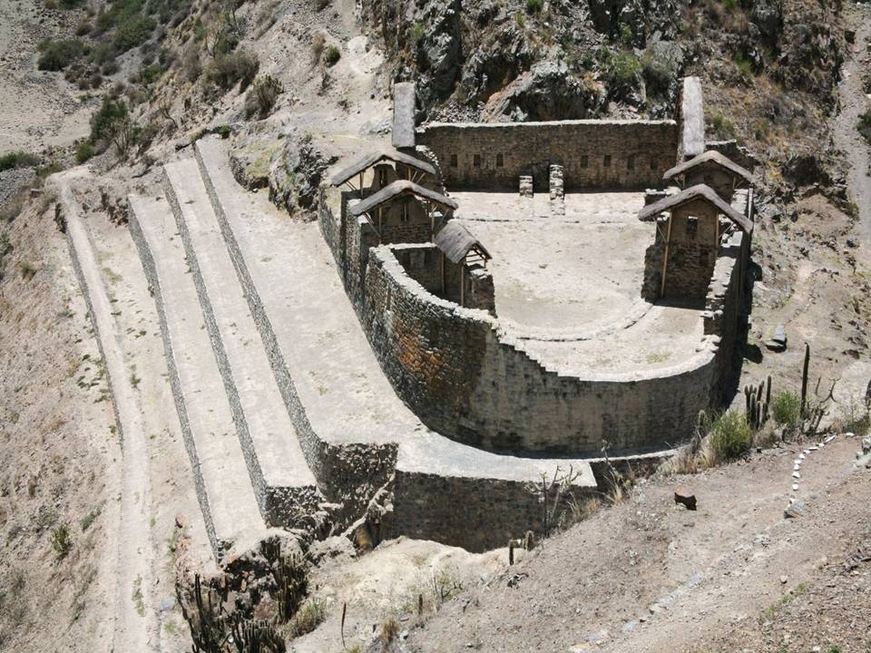
Description of Choquequirao
Choquequirao complex consists of nine sectors, most notably the political and religious center, the source system of aqueducts and canals, and the group covers.


Topography
From an aerial view or at a distance, it is easy to distinguish typical Inca terraces that make up the largest buildings of Choquequirao. A Temple, some administrative buildings, rooms for managers and senior advisors who were located around the central square.
Towards the outskirts of the center of the citadel include rooms used for the rest of the population, which are grouped forming a small village. In Choquequiero numerous irrigation channels and aqueducts for potable water supply. Despite the time and the weather, most of the buildings of the "sacred sister" of Machu Picchu are well preserved, and its restoration will last, according to some scholars who are in charge, even several years.
Strategic Position
Andean perspective is undoubtedly strategic location, which allowed him to cover this unique settlement and have a stranglehold on what could be considered one of the most extraordinary journeys in the country altitude.
In turn, from the air to the researchers, who have appreciated, say Choquequirao is shown as a great book, with the mighty Apurimac river at his feet and a large mountain that plunges into the eastern slopes covered by an immense tropical vegetation, being another example of the Andean attempt to dominate the world from above.


Weather
The weather at the Shrine of Choquequirao is mild, because of his height, but rather must be emphasized that the road or path that leads to Choquequirao is hot because of the Apurimac canyon.
Architecture
Even if only 30 percent from 1.810 hectares of the complex have been rescued, we may assume that Choquequirao was more than a fortress, a religious site. For its location is likely to have been the most important religious center and was occupied by priests and those consecrated to the gods. It has been found paintings and cemeteries that would confirm this theory. Choquequirao is arranged in nine areas and small villages built around a large plaza where all the roads from each area. It has been able to locate the upper plaza (Hanan), deposits (Qolqa), the main square (Huaqaypata), the lower square (Hurin), the system of cultivation terraces immediately to the main square (Chaqra Anden), the ceremonial platform (Ushno) and housing for the priests in the bottom of the hill .. Therefore it is assumed that Choquequirao was a great political and economic center, which served as cultural and commercial enclave between the sea, mountains and jungle.
Choquequirao has many two-story buildings with niches inside. In addition to some doors and niches made with adobe jamb and irrigation canals. The material was quarried stones are used clay mortar. There are 22 recordings in these stones with figures known as "Flames of the Sun" ready in 15 to address the snowy sidewalks Quory Hauyrachina Choquequirao has a great set of platforms, a feature of the Incan villages, helping with the agricultural use of the slopes of the hills, and now, in view of the visitors seem carpeted floors by the vegetation of the area. According to archaeologist Luis Guillermo Lumbreras, Choquequirao gives the impression of having been a growing urban center, part of a larger project that much more remained incomplete.


Hike Choquequirao
This experience of trekking has a distance of 60 kilometers for 4 days, takes place in one of the world's deepest canyons, formed by the Apurimac River, through narrow, winding paths, majestic mountains and facing terrifying precipices With beautiful scenery and vegetation ranging from the bunch grass of the highlands to the tropical ferns, but can only be done if you have the advice of an experienced guide.


Four Lakes
Located 114 kilometers from Cusco, in the province of Acomayo. The four lakes are located in the upper river Vilcanota. The names of the gaps are: Pomacanchi, Acopia, Asnaqocha (lagoon odor), and lagoon Pampamarca. The sport fishing is carried out especially in the latter.


Queshuachaca Suspension Bridge
Located 143 kilometers from Cusco, in the province of Canas. One of the most important characteristics is that every three days every second Sunday of June, the bridge is woven by hand. About 1000 community members engaged in this task by using woven straw. This work will run from before the time of the Incas. The bridge ends on the fourth day, giving way to the singing and dancing. From this bridge you can see the canyon of the Apurimac River.


Paucartambo
A 110 km of Cusco is Paucartambo, the "World Summit", a town on the access to one of the last remaining wildernesses on the planet's biosphere reserve of the Manu National Park, a place that visitors come worldwide. Paucartambo also called "land of the east" and not for less, because in its territory there are many attractions, among which are:
Tres Cruces de Oro
Located 145 kilometers from Cusco. This town is a natural lookout on the edge of the Manu Biosphere Reserve. In this place the natural phenomenon "white lightning"when the sun rises in the skyline. This peculiar wobble of sunlight takes place at dawn on winter solstice, June 22. Situated at an altitude of 3,739 m and 35 km from the city of Paucartambo. In the months of May, June and July the sun king to his departure from East presents a spectacle of nature with a variety of colors, shapes and shades, all this show is appreciated from the balcony Acjanaco natural.


Looking point of Tres Cruces
Archaeological Ensemble of Watoqto
Solid Inka architectural monument, located at km 100 on the road Cusco - Paucartambo, 12 km of diversion and 2.930 m, the set is accessed by a double door jamb, on the site are appreciated builds a great Temple of rectangular shape with trapezoidal niches, also you can see another building "qosqo" circular and other facilities, on the hill adjacent to another archaeological site identified the two areas are completely fenced, the, walls of buildings are slightly. indinados, also the material used is slate gray. The complex is strategically located to Mapacho River basin.
Ninamarca Chullpas
Situated at an altitude of 57km 3.000msnm to the city of Cusco, the archaeological complex consists of 17 chullpas 2.5 to one meter in height and a diameter of 0.80 to 1.60 was used in building stone with clay mortar, the present chullpas roof overhangs to like aisles.


Paucartambo dances
In Paucartambo was celebrated traditional festivities of the Virgen del Carmen. Paucartambo be characterized as folk province of Cusco and Peru. Between 15 and return July 18 to celebrate the festivities of the Virgen del Carmen, religious festival has its roots in the colonial era, in which the waste of colorful dances and processions give a hint of the extraordinary major manifestations of faith in Peru.
The origins of the consecration of the feast of the Virgen del Carmen is known for the oral tradition of the colonial and republican. The cult of the Virgen del Carmen began in the seventeenth century, when people "Qollas" the highlands arrived driving their herds of llamas, and Kcosóipata Paucartambo through with late trading of its products. In one of these many trips to the amazement of migrants and natives, there is the miraculous appearance of the face in relief of the Virgin, in a clay pot. This finding was collected to perpetuate the complete picture, which was sculpted by artists Paucartambo, also built a temple where they worshiped with prayers and chants.


Sources:
http://www.perucontact.com/
http://www.unique-southamerica-travel-experience.com/cusco.html
http://eldiwan2010.blogspot.com/2010_10_01_archive.html
http://www.covitour.com.pe/
http://www.grupoavych.com/cusco
http://imagenes.viajeros.com/fotos
http://wiki.sumaqperu.com/es/Qenko
http://www.delange.org/Quenko/Quenko.htm
http://images.travelpod.com/
http://es.wikipedia.org/wiki/
http://www.moon.com/files/map-images/
http://www.aatccusco.com/mapas_y_planos.php
http://cuscotravelinfo.wordpress.com/
http://www.cusco-peru.org/
http://www.cuscoonline.com/
http://www.pasaporteblog.com/
http://cuzco-peru.travel/
http://perudanzas.espacioblog.com/
http://www.aboutcusco.com/
http://www.livinginperu.com/blogs/travel/1484
http://skyscraperperu.com/
http://arquitecturaytecnologia2007.blogspot.com/
http://es.wikipedia.org/wiki/Choquequirao
RELATED READINGS
Cusco: Meaning, Location and Size, Boundaries, Distances, Weather, History, the ancient Inca city
Cusco comes from the Quechua word QOSQO meaning navel, is credited with many meanings including mestizo chronicler Inca Garcilaso de la Vega who attributes the meaning of "center or navel of the world." ... Read more
Cusco: Nearby Attractions
The city of Cusco, whose name in Quechua is Qosqo, is the historical capital of Peru. It is located in the southern highlands. It now has a population of approximately 300,000 and is the largest tourist destination in Peru. Was capital of the Inca Empire and declared ... Read More
Most Popular Tourist Attractions
Sacred Valley of the Incas
The Sacred Valley of the Incas is composed of many rivers flowing through gorges and valleys, has many archaeological monuments and indigenous peoples. ... Read more
Other attractions Sightseeing in Cusco Department
Choquequirao: Gold Mine
It is located 3033 meters above sea level in the foothills of Mount Salkantay, north of the Apurimac River valley, in the province of the Convention in the department of Cusco. Choquequirao environment is one ... Read more
Machu Picchu: Description and History
Machu Picchu, one of the wonders of the modern world, is one of the archaeological sites that attract much interest around the world, is without doubt the greatest example of the work and dedication of the Andean people. Surrounded by a great forest and towering mountains, mystery... Read more
Machu Picchu, one of the wonders of the modern world, is one of the archaeological sites that attract much interest around the world, is without doubt the greatest example of the work and dedication of the Andean people. Surrounded by a great forest and towering mountains, mystery... Read more
Getting to Machu Picchu by Train.
One trip you will never forget is that you make to Machu Picchu, the sacred citadel of the Incas. The trip is made by train from Cusco or from the village of Ollantaytambo to Aguas Calientes visiting interesting and picturesque villages. There are several train services ... Read more
One trip you will never forget is that you make to Machu Picchu, the sacred citadel of the Incas. The trip is made by train from Cusco or from the village of Ollantaytambo to Aguas Calientes visiting interesting and picturesque villages. There are several train services ... Read more
Getting to Machu Picchu along the Inca Trail (1)
The Inca Trail is a walk that starts from the legendary 82 km, near Ollantaytambo, includes a path along which you can find different ecoregions, altitude, temperature range and unforgettable panoramas that will make your visit an unforgettable experience, the path that ... Read more
Getting to Machu Picchu along the Inca Trail (2)
Entry Costs
The prices seen below are only the ticket price for entry to the Inca Trail route, does not include other ... Read moreEntry Costs


Create a playlist at MixPod.com
This Salkantay Trekking itinerary sounds like an incredible adventure! From the stunning Andean peaks to the lush jungles, it offers a diverse and unforgettable experience. The journey to Machu Picchu is undoubtedly rewarding, and the tips provided will surely help trekkers prepare for this once-in-a-lifetime adventure.
ReplyDeleteDiscover avian wonders on the Machu Picchu Manu Road with BirdsofPeruTours. Traverse diverse habitats, from cloud forests to lowland rainforests, encountering vibrant species like the Andean Cock-of-the-Rock. Let our expert guides enrich your journey, combining birding excellence with the mystique of Machu Picchu. Unveil the magic of Peru's birdlife with BirdsofPeruTours.
ReplyDelete